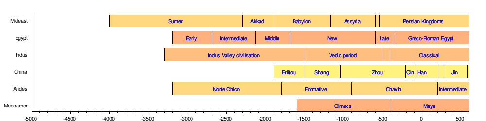
Bar
chart showing the development of civilised man from 4000 BC
to 600 AD
Before
the Cradles of Civilization could move into top gear, the
Cradles of Mankind needed to develop humans from their
ancient cousins at places like the Gauteng
Province, South Africa, and Olduvai Gorge
in Tanzania. These are two of the most important paleoanthropological localities in the
world. Both World Heritage Sites.
CRADLES
OF CIVILIZATION
A
cradle of civilization is a location and a culture where
civilization was created independent of other civilizations
in other locations. The formation of urban settlements
(cities) is the primary characteristic of a society that can
be characterized as "civilized". Other
characteristics of civilization include a sedentary
non-nomadic population,
monumental architecture, the existence of social classes and
inequality, and the creation of a writing system for
communication. The transition from simpler societies to the
complex society of a civilization is gradual.
Scholars generally acknowledge six cradles of civilization.
Mesopotamia, Ancient Egypt, Ancient India, and Ancient China
are believed to be the earliest in the Old World. Cradles of
civilization in the New World are the Caral-Supe
civilization of coastal Peru and the Olmec civilization of
Mexico. All of the cradles of civilization depended upon
agriculture for sustenance (except possibly Caral-Supe which
may have depended initially on marine resources). All
depended upon farmers producing an agricultural surplus to
support the centralized government, political leaders,
priests, and public works of the urban centers of the
civilization.
Less formally, the term "cradle of civilization"
is often used to refer to other historic ancient
civilizations, such as Greece or Rome, which have both been
called the "cradle of Western civilization".
RISE OF CIVILIZATION
The earliest signs of a process leading to sedentary culture
can be seen in the Levant to as early as 12,000 BC, when the
Natufian culture became sedentary; it evolved into an
agricultural society by 10,000 BC. The importance of water
to safeguard an abundant and stable food supply, due to
favourable conditions for hunting, fishing
and gathering resources including cereals, provided an
initial wide spectrum economy that triggered the creation of
permanent villages.
The earliest proto-urban settlements with several thousand
inhabitants emerged in the Neolithic which began in Western
Asia in 10,000 BC. The first cities to house several tens of
thousands were Uruk, Ur, Kish and Eridu in Mesopotamia,
followed by Susa in Elam and Memphis in Egypt, all by the
31st century BC (see Historical urban community sizes).
Historic times are marked apart from prehistoric times when
"records of the past begin to be kept for the benefit
of future generations" — in written or oral form. If
the rise of civilization is taken to coincide with the
development of writing out of proto-writing, then the Near
Eastern Chalcolithic (the transitional period between the
Neolithic and the Bronze Age during the 4th millennium BC)
and the development of proto-writing in Harappa in the Indus
Valley of South Asia around 3,300 BC are the earliest
instances, followed by Chinese proto-writing evolving into
the oracle bone script, and again by the emergence of
Mesoamerican writing systems from about 900 BC.
In the absence of written documents, most aspects of the
rise of early civilizations are contained in archaeological
assessments that document the development of formal
institutions and the material culture. A
"civilized" way of life is ultimately linked to
conditions coming almost exclusively from intensive
agriculture. Gordon Childe defined the development of
civilization as the result of two successive revolutions:
the Neolithic Revolution of Western Asia, triggering the
development of settled communities, and the Urban revolution
which also first emerged in Western Asia, which enhanced
tendencies towards dense settlements, specialized
occupational groups, social classes, exploitation of
surpluses, monumental public buildings and writing.
Few
of those conditions, however, are unchallenged by the
records: dense cities were not attested in Egypt's Old
Kingdom (unlike Mesopotamia) and cities had a dispersed
population in the Maya area; the Incas lacked writing
although they could keep records with Quipus which might
also have had literary uses; and often monumental
architecture preceded any indication of village settlement.
For instance, in present-day Louisiana, researchers have
determined that cultures that were primarily nomadic
organized over generations to build earthwork mounds at
seasonal settlements as early as 3400 BC. Rather than a
succession of events and preconditions, the rise of
civilization could equally be hypothesized as an accelerated
process that started with incipient agriculture and
culminated in the Oriental Bronze Age.
MULTIPLE
OF CRADLES
Scholars once thought that civilization began in the Fertile
Crescent and spread out from there by influence. Scholars
now believe that civilizations arose independently at
several locations in both hemispheres. They have observed
that sociocultural developments occurred along different
timeframes. "Sedentary" and "nomadic"
communities continued to interact considerably; they were
not strictly divided among widely different cultural groups.
The concept of a cradle of civilization has a focus where
the inhabitants came to build cities, to create writing
systems, to experiment in techniques for making pottery and
using metals, to domesticate animals, and to develop complex
social structures involving class systems.
Scholarship generally identifies six areas where
civilization emerged independently:
1 - Fertile Crescent
2 - Mesopotamia Including the (Tigris–Euphrates Valley)
and the Levant
3 - Nile Valley
4 - Indo-Gangetic Plain
5 - North China Plain
6 - Andean Coast
7 - Mesoamerican Gulf Coast
A question that intrigues scholars is why pristine
civilizations rose when and where they did. The economies of
all of the pristine civilizations depended upon agriculture,
with the possible exception of the Andean coast civilization
which may have initially relied as much or more on marine
resources. Jared Diamond postulates that the reason the
Fertile Crescent was the earliest civilization was that
large-seeded, easily-domesticable plants (wheat and barley,
among others) and large domesticable animals (cattle,
pigs,
sheep,
horses)
were native to the region. By contrast, it took thousands of
years of selective breeding in Mesoamerica for maize to
become productive enough to be a staple crop. Mesoamerica
also lacked large domesticable animals. Llamas were the only
large, domesticable animal in the Andes of South America.
Llamas are large enough to be pack animals but not large
enough to be ridden or used as draft animals. Australia
lacked both easily domesticable plants and large animals.
1
- FERTILE CRESCENT
The Fertile Crescent of 7500 BC was an arc of hilly land in
Northwest Asia that stretches from parts of modern Palestine
and Israel through Lebanon, Syria, Jordan, Turkey, and Iraq
to the Zagros Mountains in Iran. It was one of the oldest
areas in the world in which agriculture was practiced and
probably the oldest area of the world in which sedentary
farming villages existed. Around 10,200 BC the first fully
developed Neolithic cultures belonging to the phases
Pre-Pottery Neolithic A (PPNA) and Pre-Pottery Neolithic B
(7600 to 6000 BC) appeared in the Fertile Crescent and from
there spread eastward towards South Asia and westward
towards Europe and North Africa. One of the most notable
PPNA settlements is Jericho, Palestine, thought to be the
world's first town (settled around 9600 BC and fortified
around 6800 BC).
Current theories and findings identify the Fertile Crescent
as the first and oldest cradle of civilization. Examples of
sites in this area are the early Neolithic site of Göbekli
Tepe (9500–8000 BC) and Çatalhöyük (7500–5700 BC).
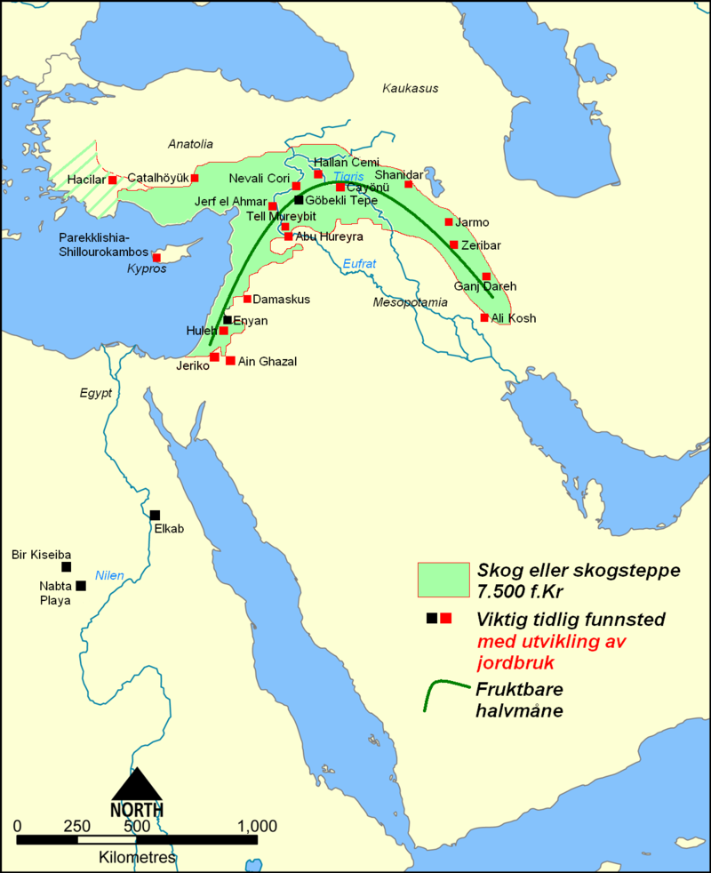
2
- MESOPOTAMIA
In Mesopotamia (a region encompassing modern Iraq and
bordering regions of Southeast Turkey, Northeast Syria and
Northwest Iran), the convergence of the Tigris and Euphrates
rivers produced rich fertile soil and a supply of water for
irrigation. Neolithic cultures emerged in the region from
8000 BC onwards. The civilizations that emerged around these
rivers are the earliest known non-nomadic agrarian
societies. It is because of this that the Fertile Crescent
region, and Mesopotamia in particular, are often referred to
as the cradle of civilization. The period known as the Ubaid
period (c. 6500 to 3800 BC) is the earliest known period on
the alluvial plain, although it is likely earlier periods
exist obscured under the alluvium. It was during the Ubaid
period that the movement toward urbanization began. Agriculture
and animal husbandry were widely practiced in sedentary
communities, particularly in Northern Mesopotamia (later
Assyria), and intensive irrigated hydraulic agriculture
began to be practiced in the south.
Around 6000 BC, Neolithic settlements began to appear all
over Egypt. Studies based on morphological, genetic, and
archaeological data have attributed these settlements to
migrants from the Fertile Crescent in the Near East arriving
in Egypt and North Africa during the Egyptian and North
African Neolithic Revolution and bringing agriculture to the
region. Tell el-'Oueili is the oldest Sumerian site settled
during this period, around 5400 BC, and the city of Ur also
first dates to the end of this period. In the south, the
Ubaid period lasted from around 6500 to 3800 BC.
Sumerian civilization coalesced in the subsequent Uruk
period (4000 to 3100 BC). Named after the Sumerian city of
Uruk, this period saw the emergence of urban life in
Mesopotamia and, during its later phase, the gradual
emergence of the cuneiform script. Proto-writing in the
region dates to around 3800 BC, with the earliest texts
dating to 3300 BC; early cuneiform writing emerged in 3000
BC. It was also during this period that pottery painting
declined as copper started to become popular, along with
cylinder seals. Sumerian cities during the Uruk period were
probably theocratic and were most likely headed by a
priest-king (ensi), assisted by a council of elders,
including both men and women. It is quite possible that the
later Sumerian pantheon was modeled upon this political
structure.
The Jemdet Nasr period, which is generally dated from 3100
to 2900 BC and succeeds the Uruk period, is known as one of
the formative stages in the development of the cuneiform
script. The oldest clay tablets come from Uruk and date to
the late fourth millennium BC, slightly earlier than the
Jemdet Nasr Period. By the time of the Jemdet Nasr Period,
the script had already undergone a number of significant
changes. It originally consisted of pictographs, but by the
time of the Jemdet Nasr Period it was already adopting
simpler and more abstract designs. It is also during this
period that the script acquired its iconic wedge-shaped
appearance.
Uruk trade networks started to expand to other parts of
Mesopotamia and as far as North Caucasus, and strong signs
of governmental organization and social stratification began
to emerge, leading to the Early Dynastic Period (c. 2900
BC). After the Early Dynastic period began, there was a
shift in control of the city-states from the temple
establishment headed by council of elders led by a priestly
"En" (a male figure when it was a temple for a
goddess, or a female figure when headed by a male god)
towards a more secular Lugal (Lu = man, Gal = great).
The
Lugals included such legendary patriarchal figures as
Enmerkar, Lugalbanda and Gilgamesh, who supposedly reigned
shortly before the historic record opens around 2700 BC,
when syllabic writing started to develop from the early
pictograms. The center of Sumerian culture remained in
southern Mesopotamia, even though rulers soon began
expanding into neighboring areas. Neighboring Semitic
groups, including the Akkadian speaking Semites (Assyrians,
Babylonians) who lived alongside the Sumerians in
Mesopotamia, adopted much of Sumerian culture for their own.
The earliest ziggurats began near the end of the Early
Dynastic Period, although architectural precursors in the
form of raised platforms date back to the Ubaid period.
The
Sumerian King List dates to the early second millennium BC.
It consists of a succession of royal dynasties from
different Sumerian cities, ranging back into the Early
Dynastic Period. Each dynasty rises to prominence and
dominates the region, only to be replaced by the next. The
document was used by later Mesopotamian kings to legitimize
their rule. While some of the information in the list can be
checked against other texts such as economic documents, much
of it is probably purely fictional, and its use as a
historical document is limited.
Eannatum, the Sumerian king of Lagash, established the first
verifiable empire in history in 2500 BC. The neighboring
Elam, in modern Iran, was also part of the early
urbanization during the Chalcolithic period. Elamite states
were among the leading political forces of the Ancient Near
East. The emergence of Elamite written records from around
3000 BC also parallels Sumerian history, where slightly
earlier records have been found. During the 3rd millennium
BC, there developed a very intimate cultural symbiosis
between the Sumerians and the Akkadians. Akkadian gradually
replaced Sumerian as a spoken language somewhere between the
3rd and the 2nd millennia BC.
The
Semitic-speaking Akkadian empire emerged around 2350 BC
under Sargon the Great. The Akkadian Empire reached its
political peak between the 24th and 22nd centuries BC. Under
Sargon and his successors, the Akkadian language was briefly
imposed on neighboring conquered states such as Elam and
Gutium. After the fall of the Akkadian Empire and the
overthrow of the Gutians, there was a brief reassertion of
Sumerian dominance in Mesopotamia under the Third Dynasty of
Ur. After the final collapse of Sumerian hegemony in
Mesopotamia around 2004 BC, the Semitic Akkadian people of
Mesopotamia eventually coalesced into two major Akkadian-speaking
nations: Assyria in the north (whose earliest kings date to
the 25th century BC), and, a few centuries later, Babylonia
in the south, both of which (Assyria in particular) would go
on to form powerful empires between the 20th and 6th
centuries BC. The Sumerians were eventually absorbed into
the Semitic Assyrian-Babylonian population.
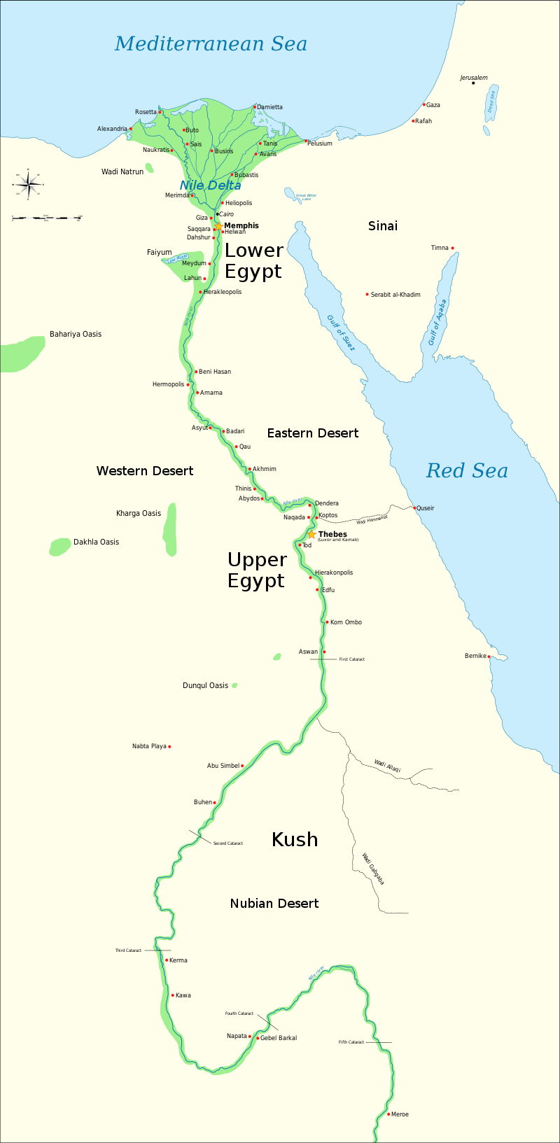
3 - ANCIENT EGYPT
The developed Neolithic cultures belonging to the phases
Pre-Pottery Neolithic A (10,200 BC) and Pre-Pottery
Neolithic B (7600 to 6000 BC) appeared in the fertile
crescent and from there spread eastwards and westwards.
Contemporaneously, a grain-grinding culture using the
earliest type of sickle blades had replaced the culture of
hunters, fishers, and gathering people using stone tools
along the Nile.
Geological evidence and computer
climate
modeling studies also suggest that natural climate changes
around 8000 BC began to desiccate the extensive pastoral
lands of northern Africa, eventually forming the Sahara.
Continued desiccation forced the early ancestors of the Egyptians
to settle around the Nile more permanently and to adopt a
more sedentary lifestyle. The oldest fully developed
neolithic culture in Egypt is Fayum A culture that began
around 5500 B.C.
By about 5500 BC, small tribes living in the Nile valley had
developed into a series of inter-related cultures as far
south as Sudan, demonstrating firm control of agriculture
and animal husbandry, and identifiable by their pottery and
personal items, such as combs, bracelets, and beads. The
largest of these early cultures in upper Southern Egypt was
the Badari, which probably originated in the Western Desert;
it was known for its high quality ceramics, stone tools, and
use of copper. The oldest known domesticated bovine in
Africa are from Fayum dating to around 4400 BC. The Badari
cultures was followed by the Naqada culture, which brought a
number of technological improvements. As early as the first
Naqada Period, Amratia, Egyptians imported obsidian from
Ethiopia, used to shape blades and other objects from
flakes. By 3300 BC, just before the first Egyptian dynasty,
Egypt was divided into two kingdoms, known as Upper Egypt to
the south, and Lower Egypt to the north.
Egyptian civilization begins during the second phase of the
Naqada culture, known as the Gerzeh period, around 3500 BC
and coalesces with the unification of Upper and Lower Egypt
around 3150 BC. Farming produced the vast majority of food;
with increased food supplies, the populace adopted a much
more sedentary lifestyle, and the larger settlements grew to
cities of about 5,000 residents. It was in this time that
the city dwellers started using mud brick to build their
cities, and the use of the arch and recessed walls for
decorative effect became popular. Copper instead of stone
was increasingly used to make tools and weaponry. Symbols on
Gerzean pottery also resemble nascent Egyptian hieroglyphs.
Early evidence also exists of contact with the Near East,
particularly Canaan and the Byblos coast, during this time.
Concurrent with these cultural advances, a process of
unification of the societies and towns of the upper Nile
River, or Upper Egypt, occurred. At the same time the
societies of the Nile Delta, or Lower Egypt, also underwent
a unification process. During his reign in Upper Egypt, King
Narmer defeated his enemies on the Delta and merged both the
Kingdom of Upper and Lower Egypt under his single rule.
The Early Dynastic Period of Egypt immediately followed the
unification of Upper and Lower Egypt. It is generally taken
to include the First and Second Dynasties, lasting from the
Naqada III archaeological period until about the beginning
of the Old Kingdom, c. 2686 BC. With the First Dynasty, the
capital moved from Thinis to Memphis with a unified Egypt
ruled by a god-king. The hallmarks of ancient Egyptian
civilization, such as art, architecture and many aspects of
religion, took shape during the Early Dynastic period. The
strong institution of kingship developed by the pharaohs
served to legitimize state control over the land, labor, and
resources that were essential to the survival and growth of
ancient Egyptian civilization.
Major advances in architecture, art, and technology were
made during the subsequent Old Kingdom, fueled by the
increased agricultural productivity and resulting
population, made possible by a well-developed central
administration. Some of ancient Egypt's crowning
achievements, the Giza
pyramids and Great
Sphinx, were constructed during the Old Kingdom. Under
the direction of the vizier, state officials collected
taxes, coordinated irrigation projects to improve crop
yield, drafted peasants to work on construction projects,
and established a justice system to maintain peace and
order. Along with the rising importance of a central
administration there arose a new class of educated scribes
and officials who were granted estates by the pharaoh in
payment for their services. Pharaohs also made land grants
to their mortuary cults and local temples, to ensure that
these institutions had the resources to worship the pharaoh
after his death. Scholars believe that five centuries of
these practices slowly eroded the economic power of the
pharaoh, and that the economy could no longer afford to
support a large centralized administration. As the power of
the pharaoh diminished, regional governors called nomarchs
began to challenge the supremacy of the pharaoh. This,
coupled with severe droughts between 2200 and 2150 BC, is
assumed to have caused the country to enter the 140-year
period of famine and strife known as the First Intermediate
Period.
4 - ANCIENT INDIA
One of the earliest Neolithic sites in the Indian
subcontinent is Bhirrana along the ancient Ghaggar-Hakra
riverine system in the present day state of Haryana in
India, dating to around 7600 BC. Other early sites include
Lahuradewa in the Middle Ganges region and Jhusi near the
confluence of Ganges
and Yamuna
rivers,
both dating to around 7000 BC.
The aceramic Neolithic at Mehrgarh in present day Pakistan
lasts from 7000 to 5500 BC, with the ceramic Neolithic at
Mehrgarh lasting up to 3300 BC; blending into the Early
Bronze Age. Mehrgarh is one of the earliest sites with
evidence of farming and herding in the Indian subcontinent.
It is likely that the culture centered around Mehrgarh
migrated into the Indus Valley in present day Pakistan and
became the Indus Valley Civilisation. The earliest fortified
town in the region is found at Rehman Dheri, dated 4000 BC
in Khyber Pakhtunkhwa close to River Zhob Valley in present
day Pakistan . Other fortified towns found to date are at
Amri (3600–3300 BC), Kot Diji in Sindh, and at Kalibangan
(3000 BC) at the Hakra River.
The Indus Valley Civilization starts around 3300 BC with
what is referred to as the Early Harappan Phase (3300 to
2600 BC). The earliest examples of the Indus script date to
this period, as well as the emergence of citadels
representing centralised authority and an increasingly urban
quality of life. Trade networks linked this culture with
related regional cultures and distant sources of raw
materials, including lapis lazuli and other materials for
bead-making. By this time, villagers had domesticated
numerous crops, including peas, sesame seeds, dates, and
cotton, as well as animals, including the water
buffalo.
2600 BC marks the Mature Harappan Phase during which Early
Harappan communities turned into large urban centers
including Harappa, Dholavira, Mohenjo-Daro, Lothal, Rupar,
and Rakhigarhi, and more than 1,000 towns and villages,
often of relatively small size. Mature Harappans evolved new
techniques in metallurgy and produced copper, bronze, lead,
and tin and displayed advanced levels of engineering. As
seen in Harappa, Mohenjo-daro and the recently partially
excavated Rakhigarhi, this urban plan included the world's
first known urban sanitation systems. Within the city,
individual homes or groups of homes obtained water from
wells. From a room that appears to have been set aside for
bathing, waste water
was directed to covered drains, which lined the major
streets. Houses opened only to inner courtyards and smaller
lanes. The house-building in some villages in the region
still resembles in some respects the house-building of the
Harappans. The advanced architecture of the Harappans is
shown by their impressive dockyards, granaries, warehouses,
brick platforms, and protective walls. The massive walls of
Indus cities most likely protected the Harappans from floods
and may have dissuaded military conflicts.
The people of the Indus Civilization achieved great accuracy
in measuring length, mass, and time. They were among the
first to develop a system of uniform weights and measures. A
comparison of available objects indicates large scale
variation across the Indus territories. Their smallest
division, which is marked on an ivory scale found in Lothal
in Gujarat, was approximately 1.704 mm, the smallest
division ever recorded on a scale of the Bronze Age.
Harappan engineers followed the decimal division of
measurement for all practical purposes, including the
measurement of mass as revealed by their hexahedron weights.
These chert weights were in a ratio of 5:2:1 with weights of
0.05, 0.1, 0.2, 0.5, 1, 2, 5, 10, 20, 50, 100, 200, and 500
units, with each unit weighing approximately 28 grams,
similar to the English Imperial ounce or Greek uncia, and
smaller objects were weighed in similar ratios with the
units of 0.871. However, as in other cultures, actual
weights were not uniform throughout the area. The weights
and measures later used in Kautilya's Arthashastra (4th
century BC) are the same as those used in Lothal.
Around 1800 BC, signs of a gradual decline began to emerge,
and by around 1700 BC most of the cities had been abandoned.
Suggested contributory causes for the localisation of the
IVC include changes in the course of the river, and climate
change that is also signalled for the neighbouring areas of
the Middle East. As of 2016 many scholars believe that
drought led to a decline in trade with Egypt and Mesopotamia
contributing to the collapse of the Indus Civilization. The
Ghaggar-Hakra system was rain-fed, and water-supply depended
on the monsoons. The Indus Valley climate grew significantly
cooler and drier from about 1800 BC, linked to a general
weakening of the monsoon at that time. The Indian monsoon
declined and aridity increased, with the Ghaggar-Hakra
retracting its reach towards the foothills of the Himalaya,
leading to erratic and less extensive floods that made
inundation agriculture less sustainable. Aridification
reduced the water
supply enough to cause the civilization's demise, and to
scatter its population eastward. As the monsoons kept
shifting south, the floods grew too erratic for sustainable
agricultural activities. The residents then migrated away
into smaller communities. However trade with the old cities
did not flourish. The small surplus produced in these small
communities did not allow development of trade, and the
cities died out. The Indo-Aryan peoples migrated into the
Indus River Valley during this period and began the Vedic
age of India. The Indus Valley Civilization did not
disappear suddenly and many elements of the civilization
continued in later Indian subcontinent and Vedic cultures.
5 - ANCIENT CHINA
Drawing on archaeology, geology and anthropology, modern
scholars do not see the origins of the Chinese civilization
or history as a linear story but rather the history of the
interactions of different and distinct cultures and ethnic
groups that influenced each other's development. The
specific cultural regions that developed Chinese
civilization were the Yellow River civilization, the Yangtze
civilization, and Liao civilization. Early evidence for
Chinese millet agriculture is dated to around 7000 BC, with
the earliest evidence of cultivated rice found at
Chengtoushan near the Yangtze River, dated to 6500 BC.
Chengtoushan may also be the site of the first walled city
in China. By the beginning of the Neolithic Revolution, the
Yellow River valley began to establish itself as a center of
the Peiligang culture, which flourished from 7000 to 5000
BC, with evidence of agriculture, constructed buildings,
pottery, and burial of the dead. With
agriculture came increased population,
the ability to store and redistribute crops, and the
potential to support specialist craftsmen and
administrators. Its most prominent site is Jiahu. Some
scholars have suggested that the Jiahu symbols (6600 BC) are
the earliest form of proto-writing in China. However, it is
likely that they should not be understood as writing itself,
but as features of a lengthy period of sign-use, which led
eventually to a fully-fledged system of writing.
Archaeologists believe that the Peiligang culture was
egalitarian, with little political organization.
It eventually evolved into the Yangshao culture (5000 to
3000 BC), and their stone tools were polished and highly
specialized. They may also have practiced an early form of
silkworm cultivation. The main food of the Yangshao people
was millet, with some sites using foxtail millet and others
broom-corn millet, though some evidence of rice has been
found. The exact nature of Yangshao agriculture, small-scale
slash-and-burn cultivation versus intensive agriculture in
permanent fields, is currently a matter of debate. Once the
soil was exhausted, residents picked up their belongings,
moved to new lands, and constructed new villages. However,
Middle Yangshao settlements such as Jiangzhi contain
raised-floor buildings that may have been used for the
storage of surplus grains. Grinding stones for making flour
were also found.
Later, Yangshao culture was superseded by the Longshan
culture, which was also centered on the Yellow
River from about 3000 to 1900 BC, its most prominent
site being Taosi. The population expanded dramatically
during the 3rd millennium BC, with many settlements having
rammed earth walls. It decreased in most areas around 2000
BC until the central area evolved into the Bronze Age
Erlitou culture. The earliest bronze artifacts have been
found in the Majiayao culture site (3100 to 2700 BC).
Chinese civilization begins during the second phase of the
Erlitou period (1900 to 1500 BC), with Erlitou considered
the first state level society of East Asia. There is
considerable debate whether Erlitou sites correlate to the
semi-legendary Xia dynasty. The Xia dynasty (2070 to 1600
BC) is the first dynasty to be described in ancient Chinese
historical records such as the Bamboo Annals, first
published more than a millennium later during the Western
Zhou period. Although Xia is an important element in Chinese
historiography, there is to date no contemporary written
evidence to corroborate the dynasty.
Erlitou
saw an increase in bronze metallurgy and urbanization and
was a rapidly growing regional center with palatial
complexes that provide evidence for social stratification.
The Erlitou civilization is divided into four phases, each
of roughly 50 years. During Phase I, covering 100 hectares
(250 acres), Erlitou was a rapidly growing regional center
with estimated population of several thousand but not yet an
urban civilization or capital. Urbanization began in Phase
II, expanding to 300 ha (740 acres) with a population around
11,000. A palace area of 12 ha (30 acres) was demarcated by
four roads. It contained the 150x50 m Palace 3, composed of
three courtyards along a 150-meter axis, and Palace 5. A
bronze foundry was established to the south of the palatial
complex that was controlled by the elite who lived in
palaces. The city reached its peak in Phase III, and may
have had a population of around 24,000. The palatial complex
was surrounded by a two-meter-thick rammed-earth wall, and
Palaces 1, 7, 8, 9 were built.
The
earthwork volume of rammed earth for the base of largest
Palace 1 is 20,000 m³ at least. Palaces 3 and 5 were
abandoned and replaced by 4,200-square-meter (45,000 sq ft)
Palace 2 and Palace 4. In Phase IV, the population decreased
to around 20,000, but building continued. Palace 6 was built
as an extension of Palace 2, and Palaces 10 and 11 were
built. Phase IV overlaps with the Lower phase of the
Erligang culture (1600–1450 BC). Around 1600 to
1560 BC, about 6 km northeast of Erlitou, a culturally
Erligang walled city was built at Yanshi, which coincides
with an increase in production of arrowheads at Erlitou.
This situation might indicate that the Yanshi city was
competing for power and dominance with Erlitou. Production
of bronzes and other elite goods ceased at the end of Phase
IV, at the same time as the Erligang city of Zhengzhou was
established 85 km (53 mi) to the east. There is no evidence
of destruction by fire or war, but, during the Upper
Erligang phase (1450–1300 BC), all the palaces were
abandoned, and Erlitou was reduced to a village of 30 ha (74
acres).
The earliest traditional Chinese dynasty for which there is
both archeological and written evidence is the Shang dynasty
(1600 to 1046 BC). Shang sites have yielded the earliest
known body of Chinese writing, the oracle bone script,
mostly divinations inscribed on bones. These inscriptions
provide critical insight into many topics from the politics,
economy, and religious practices to the art and medicine of
this early stage of Chinese civilization. Some historians
argue that Erlitou should be considered an early phase of
the Shang dynasty. The U.S. National Gallery of Art defines
the Chinese Bronze Age as the period between about 2000 and
771 BC; a period that begins with the Erlitou culture and
ends abruptly with the disintegration of Western Zhou rule.
The Sanxingdui culture is another Chinese Bronze Age
society, contemporaneous to the Shang dynasty, however they
developed a different method of bronze-making from the Shang.
6 - ANCIENT ANDES
The earliest evidence of agriculture
in the Andean region dates to around 9000 BC in Ecuador at
sites of the Las Vegas culture. The bottle gourd may have
been the first plant cultivated. The oldest evidence of
canal irrigation in South America dates to 4700 to 2500 BC
in the Zaña Valley of northern Peru. The earliest urban
settlements of the Andes, as well as North and South
America, are dated to 3500 BC at Huaricanga, in the
Fortaleza area, and Sechin Bajo near the Sechin River. Both
sites are in Peru.
The Caral-Supe or Norte Chico civilization is understood to
have emerged around 3200 BC, as it is at that point that
large-scale human settlement and communal construction
across multiple sites becomes clearly apparent. In the early
21st century, Peruvian archaeologist Ruth Shady established
Caral-Supe as the oldest known civilization in the Americas.
The civilization flourished near the Pacific coast in the
valleys of three small rivers, the Fortaleza, the Pativilca,
and the Supe. These river valleys each have large clusters
of sites. Further south, there are several associated sites
along the Huaura River.
Notable
settlements include the cities of Caral, the largest and
most complex Preceramic site, and Aspero. Norte Chico is
distinguished by its density of large sites with immense
architecture. Haas argues that the density of sites in such
a small area is globally unique for a nascent civilization.
During the third millennium BC, Norte Chico may have been
the most densely populated area of the world (excepting,
possibly, northern China). The Supe, Pativilca, Fortaleza,
and Huaura River valleys each have several related sites.
Norte Chico is unusual in that it completely lacked ceramics
and apparently had almost no visual art. Nevertheless, the
civilization exhibited impressive architectural feats,
including large earthwork platform mounds and sunken
circular plazas, and an advanced textile industry. The
platform mounds, as well as large stone warehouses, provide
evidence for a stratified society and a centralized
authority necessary to distribute resources such as cotton.
However, there is no evidence of warfare or defensive
structures during this period. Originally, it was theorized
that, unlike other early civilizations, Norte Chico
developed by relying on maritime food sources in place of a
staple cereal. This hypothesis, the Maritime Foundation of
Andean Civilization, is still hotly debated; however, most
researches now agree that agriculture played a central role
in the civilization's development while still acknowledging
a strong supplemental reliance on maritime proteins.
The Norte Chico chiefdoms were "...almost certainly
theocratic, though not brutally so," according to Mann.
Construction areas show possible evidence of feasting, which
would have included music and likely alcohol, suggesting an
elite able to both mobilize and reward the population. The
degree of centralized authority is difficult to ascertain,
but architectural construction patterns are indicative of an
elite that, at least in certain places at certain times,
wielded considerable power: while some of the monumental
architecture was constructed incrementally, other buildings,
such as the two main platform mounds at Caral, appear to
have been constructed in one or two intense construction
phases.
As
further evidence of centralized control, Haas points to
remains of large stone warehouses found at Upaca, on the
Pativilca, as emblematic of authorities able to control
vital resources such as cotton. Economic authority would
have rested on the control of cotton and edible plants and
associated trade relationships, with power centered on the
inland sites. Haas tentatively suggests that the scope of
this economic power base may have extended widely: there are
only two confirmed shore sites in the Norte Chico (Aspero
and Bandurria) and possibly two more, but cotton fishing
nets and domesticated plants have been found up and down the
Peruvian coast. It is possible that the major inland centers
of Norte Chico were at the center of a broad regional trade
network centered on these resources.
Discover magazine, citing Shady, suggests a rich and varied
trade life: "[Caral] exported its own products and
those of Aspero to distant communities in exchange for
exotic imports: Spondylus shells from the coast of Ecuador,
rich dyes from the Andean highlands, hallucinogenic snuff
from the Amazon." (Given the still limited extent of
Norte Chico research, such claims should be treated
circumspectly.) Other reports on Shady's work indicate Caral
traded with communities in the Andes and in the jungles of
the Amazon basin on the opposite side of the Andes.
Leaders' ideological power was based on apparent access to
deities and the supernatural. Evidence regarding Norte Chico
religion is limited: an image of the Staff God, a leering
figure with a hood and fangs, has been found on a gourd
dated to 2250 BC. The Staff God is a major deity of later
Andean cultures, and Winifred Creamer suggests the find
points to worship of common symbols of gods. As with much
other research at Norte Chico, the nature and significance
of the find has been disputed by other researchers. The act
of architectural construction and maintenance may also have
been a spiritual or religious experience: a process of
communal exaltation and ceremony. Shady has called Caral
"the sacred city" (la ciudad sagrada):
socio-economic and political focus was on the temples, which
were periodically remodeled, with major burnt offerings
associated with the remodeling.
Bundles of strings uncovered at Norte Chico sites have been
identified as quipu, a type of pre-writing recording device.
Quipu are thought to encode numeric information, but some
have conjectured that quipu have been used to encode other
forms of data, possibly including literary or musical
applications. However, the exact use of quipu by the Norte
Chico and later Andean cultures has been widely debated. The
presence of quipu and the commonality of religious symbols
suggests a cultural link between Norte Chico and later
Andean cultures.
Circa 1800 BC, the Norte Chico civilization began to
decline, with more powerful centers appearing to the south
and north along the coast and to the east inside the belt of
the Andes. Pottery eventually developed in the Amazon Basin
and spread to the Andean culture region around 2000 BC. The
next major civilization to arise in the Andes would be the
Chavín culture at Chavín de Huantar, located in the Andean
highlands of the present-day Ancash Region. It is believed
to have been built around 900 BC and was the religious and
political center of the Chavín people.
7 - MESOAMERICA
Maize is believed to have been first domesticated in
southern Mexico about 7000 BC. The Coxcatlan Caves in the
Valley of Tehuacán provide evidence for agriculture in
components dated between 5000 and 3400 BC. Similarly, sites
such as Sipacate in Guatemala provide maize pollen samples
dating to 3500 BC. Around 1900 BC, the Mokaya domesticated
one of the dozen species of cacao. A Mokaya archaeological
site provides evidence of cacao beverages dating to this
time. The Mokaya are also thought to have been among the
first cultures in Mesoamerica to develop a hierarchical
society. What would become the Olmec civilization had its
roots in early farming cultures of Tabasco, which began
around 5100 to 4600 BC.
The emergence of the Olmec civilization has traditionally
been dated to around 1600 to 1500 BC. Olmec features first
emerged in the city of San Lorenzo Tenochtitlán, fully
coalescing around 1400 BC. The rise of civilization was
assisted by the local ecology of well-watered alluvial soil,
as well as by the transportation network provided by the
Coatzacoalcos River
basin. This environment encouraged a densely concentrated
population, which in turn triggered the rise of an elite
class and an associated demand for the production of the
symbolic and sophisticated luxury artifacts that define
Olmec culture. Many of these luxury artifacts were made from
materials such as jade, obsidian, and magnetite, which came
from distant locations and suggest that early Olmec elites
had access to an extensive trading network in Mesoamerica.
The
aspect of Olmec culture perhaps most familiar today is their
artwork, particularly the Olmec colossal heads. San Lorenzo
was situated in the midst of a large agricultural area. San
Lorenzo seems to have been largely a ceremonial site, a town
without city walls, centered in the midst of a widespread
medium-to-large agricultural population. The ceremonial
center and attendant buildings could have housed 5,500 while
the entire area, including hinterlands, could have reached
13,000. It is thought that while San Lorenzo controlled much
or all of the Coatzacoalcos basin, areas to the east (such
as the area where La Venta would rise to prominence) and
north-northwest (such as the Tuxtla Mountains) were home to
independent polities. San Lorenzo was all but abandoned
around 900 BC
at about the same time that La Venta rose to prominence. A
wholesale destruction of many San Lorenzo monuments also
occurred circa 950 BC, which may indicate an internal
uprising or, less likely, an invasion. The latest thinking,
however, is that environmental changes may have been
responsible for this shift in Olmec centers, with certain
important rivers changing course.
La Venta became the cultural capital of the Olmec
concentration in the region until its abandonment around 400
BC; constructing monumental architectural achievements such
as the Great Pyramid of La Venta. It contained a
"concentration of power", as reflected by the
sheer enormity of the architecture and the extreme value of
the artifacts uncovered. La Venta is perhaps the largest
Olmec city and it was controlled and expanded by an
extremely complex hierarchical system with a king, as the
ruler and the elites below him. Priests had power and
influence over life and death and likely great political
sway as well. Unfortunately, not much is known about the
political or social structure of the Olmec, though new
dating techniques might, at some point, reveal more
information about this elusive culture.
It
is possible that the signs of status exist in the artifacts
recovered at the site such as depictions of feathered
headdresses or of individuals wearing a mirror on their
chest or forehead. "High-status objects were a
significant source of power in the La Venta polity political
power, economic power, and ideological power. They were
tools used by the elite to enhance and maintain rights to
rulership". It has been estimated that La Venta would
need to be supported by a population of at least 18,000
people during its principal occupation. To add to the
mystique of La Venta, the alluvial soil did not preserve
skeletal remains, so it is difficult to observe differences
in burials. However, colossal heads provide proof that the
elite had some control over the lower classes, as their
construction would have been extremely labor-intensive.
"Other features similarly indicate that many laborers
were involved". In addition, excavations over the years
have discovered that different parts of the site were likely
reserved for elites and other parts for non-elites. This
segregation of the city indicates that there must have been
social classes and therefore social inequality.
The exact cause of the decline of the Olmec culture is
uncertain. Between 400 and 350 BC, the population in the
eastern half of the Olmec heartland dropped precipitously.
This depopulation was probably the result of serious
environmental changes that rendered the region unsuited for
large groups of farmers, in particular changes to the
riverine environment that the Olmec depended upon for
agriculture, hunting and gathering, and transportation.
These changes may have been triggered by tectonic upheavals
or subsidence, or the silting up of rivers due to
agricultural practices. Within a few hundred years of the
abandonment of the last Olmec cities, successor cultures
became firmly established. The Tres Zapotes site, on the
western edge of the Olmec heartland, continued to be
occupied well past 400 BC, but without the hallmarks of the
Olmec culture. This post-Olmec culture, often labeled
Epi-Olmec, has features similar to those found at Izapa,
some 550 km (330 miles) to the southeast.
The Olmecs are sometimes referred to as the mother culture
of Mesoamerica, as they were the first Mesoamerican
civilization and laid many of the foundations for the
civilizations that followed. However, the causes and degree
of Olmec influences on Mesoamerican cultures has been a
subject of debate over many decades. Practices introduced by
the Olmec include ritual bloodletting and the Mesoamerican
ballgame; hallmarks of subsequent Mesoamerican societies
such as the Maya and Aztec. Although the Mesoamerican
writing system would fully develop later, early Olmec
ceramics show representations that may be interpreted as
codices.

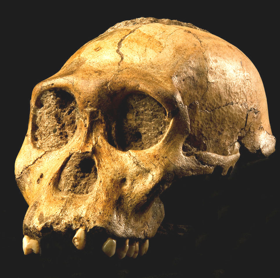
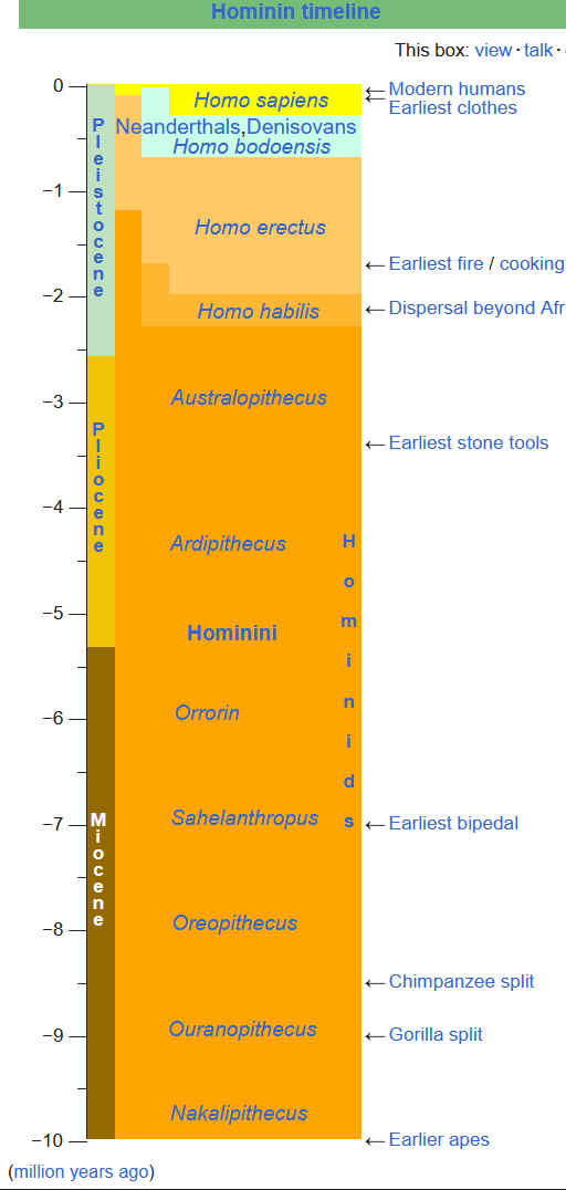
Homo habilis, (Latin: “able
man,” “handy man” "tool user") is an extinct species of
human from the early Pleistocene, the most ancient representative of the human genus, Homo.
Habilis inhabited parts of sub-Saharan East Africa from roughly 2.4 to 1.5 million years ago (mya). In 1959 and 1960 the first fossils were discovered at Olduvai Gorge in northern Tanzania. This discovery was a turning point in the science of paleoanthropology because the oldest previously known human fossils were Asian specimens of Homo erectus. Many features of
Homo Habilis appear to be intermediate in terms of evolutionary development between the relatively primitive
Australopithecus and the more-advanced
Homo Sapiens.
At all of these stages of evolution, ape men have eaten one another.
GEOLOGICAL CONTEXT
The hominin remains at the Cradle of Humankind are found in dolomitic caves, and are often encased in a mixture of limestone and other sediments called breccia that fossilised over time. Hominids may have lived all over
Africa, but their remains are found only at sites where conditions allowed for the formation and preservation of fossils.
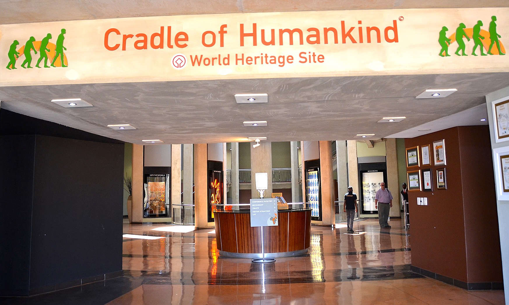
VISITOR CENTRES
On 7 December 2005, South African President Thabo Mbeki opened the new Maropeng Visitors Centre at the site. Per the maropeng.co.za website, visitors can see fossils, view stone tools, and learn about the birth of humankind in the visitors centre. The visitors centre additionally offers a tour of the Sterkfontein Caves and the exhibition at Sterkfontein. A light, moveable, steel structure known as the Beetle has been placed over the Malapa site, to allow the paying public to view excavations, once they resume at the site. (Digging has been on hold since 2009, when the remains of four A. sediba individuals were removed.)
ABOUT
GAUTENG
Gauteng is one of the nine provinces of South Africa. The name in Sotho-Tswana languages means 'place of
gold'.
Situated on the Highveld, Gauteng is the smallest province by land area in
South
Africa. Although Gauteng accounts for only 1.5% of the country's land area, it is home to more than a quarter of its population (26%). Highly urbanised, the province contains the country's largest city, Johannesburg, which is also one of the largest cities in the world. Gauteng is the wealthiest province in South Africa and is considered as the financial hub of not only South Africa but the entire African continent, mostly concentrated in Johannesburg. It also contains the administrative capital, Pretoria, and other large areas such as Midrand, Vanderbijlpark, Ekurhuleni and the affluent Sandton. Gauteng is the most populous province in South Africa with a population of approximately 16.1 million people according to mid year 2022 estimates.
The
Cradle of Humankind - UNESCO World Heritage Site
HISTORY OF GAUTENG
Gauteng was formed from part of the old Transvaal Province after South Africa's first multiracial elections on 27 April 1994. It was initially named Pretoria–Witwatersrand–Vereeniging (PWV) and was renamed "Gauteng" on the 28th of June 1995, together with two other provinces. The term "PWV" describing the region existed long before the establishment of the province, with the "V" sometimes standing for "Vaal Triangle" rather than Vereeniging.
At the Sterkfontein caves, some of the oldest fossils of hominids have been discovered, such as Mrs. Ples and Little Foot.
Gauteng's history has only been properly documented since the 19th century and as a result, not much information regarding its history predating the 19th century is available. The recorded history of the area that is now Gauteng can be traced back to the early 19th century when settlers originating from the Cape Colony defeated chief Mzilikazi and started establishing villages in the area.
The city of Pretoria was founded in 1855 as capital of the South African Republic (ZAR - Dutch: Zuid-Afrikaansche Republiek). After the discovery of gold in 1886, the region became the single largest gold producer in the world and the city of Johannesburg was founded. The older city Pretoria was not subject to the same attention and development. Pretoria grew at a slower rate and was highly regarded due to its role in the Second Boer War. The Cullinan
Diamond which is the largest
diamond ever mined was mined near Pretoria in a nearby town called Cullinan in the year 1905.
Many crucial events happened in present-day Gauteng with regards to the anti-apartheid struggle, such as the Freedom Charter of 1955, Women's March of 1956, Sharpeville massacre of 1960, the Rivonia Trial of 1963 and 1964, the little Rivonia Trial of 1964, the Soweto Uprising of 1976 and Sharpeville Six of 1984. The Apartheid Museum documents this era.
ECONOMICS
Gauteng is considered the economic hub of South Africa and contributes heavily in the financial, manufacturing, transport, technology, and telecommunications sectors, among others. It also plays host to a large number of overseas companies requiring a commercial base in and gateway to Africa.
Gauteng is home to the Johannesburg Stock Exchange, the largest stock exchange in Africa. Some of the largest companies in Africa and abroad are based in Gauteng, or have offices and branches there, such as Vodacom, MTN, Neotel, Microsoft South Africa and the largest
Porsche Centre in the world.
Although Gauteng is the smallest of South Africa's nine
provinces - it covers a mere 1.5% of the country's total land area, the province is responsible for a third of South Africa's gross domestic product (GDP). Gauteng generates about 10% of the total GDP of sub-Saharan Africa and about 7% of total African GDP.

JOHN STORM'S CONCERNS AS TO UNCONTROLLED POPULATION
GROWTH
In the
John
Storm (franchise) of ocean and innerspace adventures, the protagonist's leanings toward
anthropological and evolutionary studies, bordering on obsession,
leads him into direct contact with human remains in all
states of preservation and lack thereof. This means he is
also on point when it comes to the growing
world population, carrying with it the threat of cannibalism, such as when the
Pilgrims boat,
Mayflower,
landed at Plymouth, Massachusetts, in the New World; America
1620. Giving new meaning to the Blood of Christ.
John's
ship, the Elizabeth Swann
houses the largest, and most comprehensive DNA
database in the world, called The
Ark, from which the
Captain of the ship, working with super AI
computers, can recreate virtually any species of flora or
fauna. Including splicing and defect corrections. The human DNA
collection turns out to be a useful tool in predicting a
return to a widely spreading 'Hannibal
Lecter' style of cannibalism. That John may have to do
something to quell.
Being a naturalist, John leans
towards allowing nature to take its course, except where
human avarice is a form of natural selection, that other
more intelligent humans might do their utmost to prevent. It
is a battle ground of intelligent planning versus greedy
kleptocrats. Predicted in the Bible as Armageddon.
But
when John and his crew encounter feasting on humans, first
hand, and realizes that they could be next. He feels duty
bound to do something. And we are not just talking about
surviving attacks on his person. Where he was accidentally
injected with a CRIPSR virus, that enhanced him physically,
there were unwanted side effects. John and Dan thought to
undo the negatives, at the same time enhancing John's mental
abilities and mechanical frame. At that point they created a
new species: Homo
Sapiens Superior, or, Kanis
Rex.
The
author of the John Storm series of adventures, was born in
Johannesburg.
....
REFERENCES
https://www.